11 Lexington neighborhoods compared: ZIP codes, zoned FCPS high schools and Zillow home values for September 2026, from downtown to Masterson Station.
Last checked Oct. 16, 2026. Sources: the Lexington-Fayette Urban County Government’s open data (small area plans, H-1 historic overlays, National Register districts, the neighborhood association registry, parks, ZIP codes and address points), Fayette County Public Schools’ current attendance boundaries, the Kentucky Department of Education’s 2025-26 accountability data, the Census Bureau, OpenStreetMap and Zillow Research.
Lexington and Fayette County share one government, the Lexington-Fayette Urban County Government, so there is no line between “city” and “county” to check when you buy or rent. About 323,700 people live in the urban county, according to the Census Bureau’s 2020-2024 American Community Survey. What does change from street to street is the services district on your tax bill, the school zone and the ZIP code.
How the town is laid out:
- New Circle Road (KY 4) is a ring road around the older city, with numbered exits. Downtown, the Northside, the East End, Bell Court, Ashland Park, Cardinal Valley and Southland are inside it; Masterson Station, Beaumont, Hamburg and Andover are outside.
- I-75 and I-64 share a roadway along the north and east sides and split at Exit 111. Hamburg sits beside I-75.
- The Urban Service Area boundary, which the urban county has drawn since 1958 according to its open data, separates the urban area from the rural land around it.
- 15 ZIP codes each have at least 10% of their land inside the urban county, according to the Census Bureau’s 2020 relationship file.
- One school district, Fayette County Public Schools, assigns students by address. Zones do not follow neighborhood lines: seven of the 11 areas below are split at some grade level.
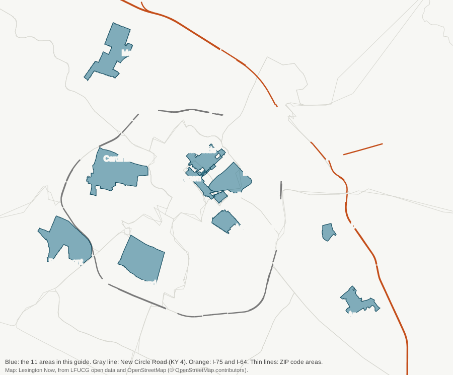
Map: Lexington Now, drawn from the urban county’s open data and OpenStreetMap (© OpenStreetMap contributors).
The 11 areas at a glance
| Area | ZIP code | Zoned high school | ZIP home value, Sept. 2026 | Guide |
|---|---|---|---|---|
| Downtown | 40507 | Lafayette or Henry Clay | $411,087 | Downtown |
| Northside | 40508 | Lafayette (92%) or Bryan Station | $225,432 | Northside |
| East End | 40508 | Frederick Douglass (80%) or Henry Clay | $225,432 | East End |
| Bell Court | 40508 | Henry Clay | $225,432 | Bell Court |
| Ashland Park | 40502 | Henry Clay | $560,691 | Ashland Park |
| Cardinal Valley | 40504 | Paul Laurence Dunbar (58%) or Lafayette | $269,418 | Cardinal Valley |
| Masterson Station | 40511 | Bryan Station | $313,248 | Masterson Station |
| Beaumont | 40513 | Paul Laurence Dunbar | $569,824 | Beaumont |
| Southland | 40503 | Lafayette | $344,639 | Southland |
| Hamburg | 40509 | Frederick Douglass | $402,163 | Hamburg |
| Andover | 40509 | Frederick Douglass | $402,163 | Andover |
Zones are from our check of the city’s residential address points against FCPS’s current attendance boundaries; always confirm an address in the SchoolSite Locator. Home values are the Zillow Home Value Index for the ZIP code, a modeled typical value for the middle third of homes, not a sale price. Lexington’s figure was $331,087. Ratings for every zoned school are on each area’s page and on our schools guide.
Downtown
The Central Business District, about 0.24 square mile, with about 970 homes, most of them apartments and condominiums, and three National Register districts. Most Lextran routes stop here. Read the Downtown guide.
Northside
The Northside Residential Historic District north of downtown, listed in 1979, about 0.44 square mile and 1,900 homes, part of it a local H-1 overlay with design review. Read the Northside guide.
East End
The 387 acres northeast of downtown covered by the city’s 2009 East End Small Area Plan, with William Wells Brown Elementary and Charles Young Park inside. Read the East End guide.
Bell Court
A small H-1 historic overlay and National Register district east of downtown, built around the Bell Place park, all zoned for Ashland Elementary and Henry Clay High. Read the Bell Court guide.
Ashland Park
The National Register district around Ashland, the Henry Clay estate, southeast of downtown, about 770 homes in ZIP code 40502. Read the Ashland Park guide.
Cardinal Valley
The west side area along Versailles Road covered by the 2015 Cardinal Valley Small Area Plan, about 12,600 residents, five city parks and the Alexandria Drive “International District” the plan names. Read the Cardinal Valley guide.
Masterson Station
A northwest neighborhood off Leestown Road, as its neighborhood association maps it, beside the 660-acre Masterson Station Park. Read the Masterson Station guide.
Beaumont
A southwest neighborhood around Beaumont Centre, as its residential association maps it, with Rosa Parks Elementary and Beaumont Preserve inside. Read the Beaumont guide.
Southland
The area around Southland Drive between Clays Mill and Nicholasville roads, as The Southland Association maps it, including the Pensacola Park historic overlay. Read the Southland guide.
Hamburg
The homes west of the Hamburg Pavilion shopping center, near I-75, in the outline OpenStreetMap draws for Hamburg. Read the Hamburg guide.
Andover
A southeast neighborhood between Jacobson Park and the Lakeside Golf Course, outlined by OpenStreetMap and its neighborhood association. Read the Andover guide.
How we built this
We defined each area only from a source we could put on a map:
- City plans: the East End and Cardinal Valley small area plans and the Central Business District boundary, from the urban county’s open data.
- Historic districts: the National Register districts for Northside, Ashland Park and Bell Court, and the H-1 overlays inside them, from the same data and the zoning ordinance.
- Neighborhood associations: the Masterson Station, Beaumont and Southland boundaries from the city’s Neighborhood Association Lookup, which lists about 210 associations registered with the Division of Planning.
- OpenStreetMap outlines for Hamburg and Andover.
For each area we checked the city’s residential address points against FCPS’s zones and the city’s ZIP code map, matched parks from the city’s park data, bus stops from Lextran’s schedule data for Oct. 5 to Dec. 19, 2026, and stores from OpenStreetMap, and measured road distances with the OSRM routing engine. We left out places with no mapped boundary, such as Chevy Chase, which OpenStreetMap marks only as a point, and we do not name individual subdivisions.
Comparing towns
Thinking about Nicholasville, Versailles or Winchester instead? Our Lexington vs Nicholasville vs Versailles vs Winchester guide compares tax rates, schools, home values and commutes from official figures.
More for newcomers: moving to Lexington, home prices, property taxes, schools, parks and trails and getting around.
Frequently asked questions
What are the neighborhoods in Lexington, Kentucky?
The urban county’s registry lists about 210 neighborhood associations. This guide covers 11 areas the city’s plans, historic districts and registry or OpenStreetMap define: Downtown, Northside, East End, Bell Court, Ashland Park, Cardinal Valley, Masterson Station, Beaumont, Southland, Hamburg and Andover.
How many school districts are in Lexington?
One. Fayette County Public Schools serves all of Lexington and Fayette County, and assigns students by home address. Seven of the 11 areas in this guide are split between two or more school zones at some grade level.
What is the typical home value in Lexington?
Zillow’s Home Value Index for Lexington was $331,087 in September 2026, up 3.4% from September 2025. By ZIP code it ranged from $225,432 in 40508 to $757,562 in 40510.
How do I find out which neighborhood association covers my address?
Use the urban county’s Neighborhood Association Lookup map, which shows every association registered with the Division of Planning.
Have your say